Off-Road Travel: Box Canyon Trail in Arizona

Dec. 05, 2016 By Kevin Blumer, Photos by Kevin Blumer and Matt Cawley

What happens when opportunity meets preparedness? A phenomenon that some like to call “luck.” Luck can sometimes be chalked up to random happenstance, but we prefer a more active approach to keeping luck on our side. We’ve found it’s possible to tilt the odds in our favor. How? By keeping our off-road rigs in good condition, and by keeping several trails on our bucket list.

A couple seasons ago, we had the chance to make some luck on the Box Canyon Trail near Florence, Arizona. We compounded our good fortune by catching a concert in Tucson to kick things off.

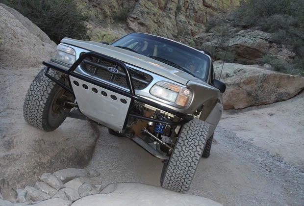
The Box Canyon Trail offers scenic views, brushes with the past, and chances to test your driving skills and your vehicle’s ground clearance. Even though civilization is nearby, Box Canyon feels remote. A fiery sunset topped off the trip.

So make your own luck. Keep your rig in good shape and create a bucket list. When opportunity meets preparedness, the trail is yours.

We caught a concert at the Rialto Theater in Tucson the night before we hit the trail. The Rialto is a longtime Tucson fixture built in 1920. Alternative rock/post-hardcore band AFI brought the house down.

Another Tucson fixture that grabbed our focus was this train trestle and its automobile underpass. See that red-and-white sign in the median? It’s a depth marker for flash floods. Tucson is ringed by mountain ranges that drain into the low-lying city. When the rain hits it’s often fast and furious.

We left Tucson using Arizona’s Highway 79 and headed towards Florence. The Tom Mix roadside memorial demanded we stop and take a look. Silent-film-era cowboy star Tom Mix’s personal trail ended here in 1940 when Mix’s 1937 Cord Phaeton careened out of control and rolled over. The monument shows Mix’s “wonder horse,” named Tony, sans its rider. Shaded picnic tables offered a place to stop for lunch, but we’d gotten a late start and were racing the short day.

The trail starts just past Florence, Arizona. Price Road intersects Highway 79 next to a railroad crossing and heads east. Initially, Price Road (A.K.A. “Price Ranch Road”) is paved as it twists past several ranches and agricultural fields.

A short time later, Price Road loses the pavement and continues its course. That’s trail leader Matt Cawley ahead of us in his long-travel 4x4 Ford Explorer.

A trailside trestle begged for a photo op.

This area is also used by the military for training exercises, some of which are live- fire. Warning signs are posted when live-fire exercises are in session. No such signs were posted during our trip, and we exchanged some friendly waves as the military personnel went by.

Box Canyon Road parts ways with Price Road, and soon thereafter enters BLM land. The afternoon shadows loomed large.

The width of the canyon chokes down in a hurry. This is a bad place to be during a rainstorm because the narrow canyon can quickly fill with raging flood water. These same flash floods can re-arrange the canyon floor with new rocky obstacles.

A few boulders seem permanently affixed to the canyon floor.

Careful wheel placement avoids body and drivetrain damage with these large boulders.

In the narrowest parts of Box Canyon you’ll have to negotiate places to pass if you encounter trail traffic. Making room for this side-by-side wasn’t too tough.

Four-door JK Wranglers are decidedly bigger than side-by-sides, but the JK’s driver made good use of his rig’s capability and straddled a boulder to let us by.

This spot required careful line selection, too. There’s a near- vertical wall on the right-hand side of the photo and the boulder in the bottom of the wash is tall enough to cause hangups. Our 4Runner’s rocker panels are unprotected so we chose this line to keep them well out of harm’s way.

For the most part, backcountry drivers are very cordial to each other. Road rage is all too common these days. Trail rage, on the other hand, is the exception and not the rule.

Box Canyon’s narrow section had one last outcropping in store.

One of Box Canyon’s attractions is an abandoned adobe dwelling. It’s a short side trip off the main line, accessed by taking the left fork at this wide junction.

There’s not much left to tell the tale of who lived here and what they may have done for a living. Odds are this dwelling had something to do with one of the many inactive mines in the area, but the adobe walls are the only ones with the true answer, and they aren’t talking.

Well, well, it looks like a well. We’ll never know how deep it may have been ‘cause it’s been filled in.

Living ocotillo branches combine with barbed wire to form a fence line.

We backtracked to the junction shown earlier and continued on the main line through Box Canyon.

The light was fading quickly. Our original plan was to follow Box Canyon’s full length and check out the town sites of DeNoon and Reymert en route to Highway 60. We’re no strangers to night ‘wheeling, but we wanted to see the good stuff in the daylight. It was time to find a bailout route.

This fenced-off mine adit hinted at what else lay in the area, giving us an incentive to return another time.

A 180-degree left-hander took us out of the Box Canyon wash and headed toward Highway 79 via Cottonwood Canyon.

The narrow shelf road offered expansive views. We’d cut our trip short but were rewarded with a classic Sonoran sunset.

A Powertank makes airing back up quick and easy. We then hit Highway 79 back toward Tucson.

We overnighted in Tucson before heading back to So Cal the next day. This sunset was captured off of the I-10 freeway near Quartzsite, Arizona.

Guidebook:Backcountry Adventures Arizona
By Peter Massey, Jeanne Wilson, and Angela Titus
(our adventure followed Central Region Trail #41: Box Canyon Trail)
Available from several sources, including Amazon.com


Off-Road.com Newsletter
Join our Weekly Newsletter to get the latest off-road news, reviews, events, and alerts!